|
Pachetul include:

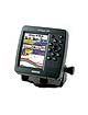
GPSMAP 498
Preloaded with U.S. marine detail maps (g2 technology)
Internal antenna
Swivel mount bracket
Protective front cover
Power data cable
Owners manual
Quick reference guide |
| |
Despre Produs
The 498C Sounder along with its counterpart, the GPSMAP 492C, give you the cartography you need to venture offshore. These versatile units come ready to launch with preloaded marine map detail utilizing the new BlueChart® g2 technology. Coverage is for U.S. coastal areas, including Alaska and Hawaii. Features include integrated mapping, 2D or 3D map perspective, tide and current data, improved IALA symbols, navaids, marinas, boat ramps, roads, and more. Both units accept preprogrammed data cards for loading additional map coverage of inland lakes or BlueChart® detail for other regions. And the GPSMAP 498C’s built-in 500-watt (RMS) sounder features Ultrascroll™ for high-speed screen updates, with the proprietary Garmin CANet™ bus enabling sounder display information to be shared with, and controlled from, another chartplotter on your boat.
Caracteristici Produs
256-color TFT display, 4.0” H x 3.0” W, 5.0-inch diagonal, 320 x 240 pixels
CCFL backlight for display and keypad
Ultra-dim backlight for nighttime operation with user programmable levels for day and night
Unit dimensions: 6.3” H x 6.3” W x 3.3” D (external antenna), 7.1” H x 6.3” W x 3.1” D (internal antenna)
Power output: 500 watts (RMS) 4000 watts (peak to peak), dual frequency 400 watts (RMS) 3200 watts (peak to peak), dual beam Depth: 1,500 feet (dual frequency), 900 feet (dual beam)
Transom mount transducer (optional): 50kHz (45 degree), 200kHz (15 degree), dual frequency
80kHz (60 degree), 200kHz (20 degree), dual beam
Built-in, highly detailed BlueChart g2 marine cartography of the coastal United States—including Alaska and Hawaii. This data provides detailed coastlines, shaded depth contours, navaids, port plans, wrecks, restricted areas, real-time tide and current information, and 3D perspective
CANet proprietary bus allows display and control of full-feature sounder data supplied from Garmin sounder
New sounder design featuring excellent shallow water performance
Ultra scroll; user adjustable
Adjustable range with automatic display re-scaling of picture
See-Thru technology: shows weak and strong returns simultaneously
Depth Control Grain (DCG): automatically adjusts fishfinder sensitivity according to depth
Power down backup of settings: customer settings are not lost when the unit is turned off
Water temperature log and graph
Round flasher display mode
A-scope
Whiteline
Adjustable depth line
2X and 4X Automatic and manual zoom
Water speed capable
Odometer
Adjustable keel offset
Alarms for fish size, shallow water, deep water, and battery voltage
Battery voltage indication
Detailed fish arches
|
