|
Pachetul include:

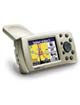
-Receptor Quest™ 2
-Cablu PC/USB
-Adaptor A/C
-Difuzor extern cu adaptor de alimentare auto
-Suport de montare pe parbrizul auto
-Manuale
-Încărcat în prealabil cu MapSource City Navigator Europe NT deblocat
|
| |
Specificatii
Moving Map Features Detailed maps:
Unit comes pre-programmed with detailed City Select® NT maps, providing street-level detail and addresses, plus listings of nearest restaurants, hotels, ATMs, etc., throughout the U.S., Canada, and Puerto Rico.
Basemap: Built-in routable basemap (Americas) contains state and country boundaries, lakes, rivers, streams, airports, cities, towns, coastlines, state and interstate highways, local thoroughfares and secondary roads within metro areas, federal interstate highway exit information for services such as food, lodging and truck, RV and automotive service stations.
Map scale: Screen-width scale 100 feet to 2,510 miles
Navigation featuresRoutes: Automatically calculated with turn-by-turn directions; up to 50 stored; auto-sorts multiple destinations to provide an efficient route for deliveries and sales calls; customizable road segment and area avoidance; fast automatic off-route and detour recalculation; “one-button home” feature quickly routes you home, no matter where you are
Waypoints: 500 with name and graphic symbol
Track log: 10,000 track log points let you retrace your path
Trip computer: Provides large speed display, odometer, stopped time, moving average, overall average, total time, max speed and more
GPS performanceReceiver: 12 parallel channel, WAAS-enabled GPS receiver continuously tracks and uses up to 12 satellites to compute and update your position
Acquisition times:
Warm: Approximately 15 seconds
Cold: Approximately 45 seconds
AutoLocate®: Approximately 2 minutes
Update rate: 1/second, continuous
GPS Accuracy:
Position: <15 meters (49 feet), 95% typical*
Velocity: 0.05 meter/sec steady state
Dynamics: 6g’s
Interfaces: USB 1.1 device
Antenna: Integral flip-up antenna; connector for optional external GPS antenna connection
Navigation featuresRoutes: Automatically calculated with turn-by-turn directions; up to 50 stored; auto-sorts multiple destinations to provide an efficient route for deliveries and sales calls; customizable road segment and area avoidance; fast automatic off-route and detour recalculation; “one-button home” feature quickly routes you home, no matter where you are
Waypoints: 500 with name and graphic symbol
Track log: 10,000 track log points let you retrace your path
Trip computer: Provides large speed display, odometer, stopped time, moving average, overall average, total time, max speed and more
PhysicalSize: 4.5" W x 2.2" H x 0.9" D (11.43 x 5.59 x 2.29 cm)
Weight: 5.5 ounces (155.92 g)
Display: 1.5" W x 2.2" H (3.81 x 5.59 cm) 160 x 240 pixels bright, 256-color, high-resolution reflective TFT with backlighting
Case: Rugged; water proof to IEC 60529 IPX7 standards (submersible 1 meter @ 30 minutes)
Temp. range: 5°F to 140°F (–15°C to 60°C)
Data storage: Indefinite; no memory battery required
Map Storage: All of North America preloaded; Supplemental areas available for downloading
Power Input: 5 Vdc
Usage: 6 watts maximum @ 13.8 Vdc
Battery: Rechargeable lithium-ion
Battery Life: Up to 20 hours
|


