|
Pachetul include:

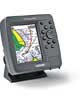
- GPSMAP 192C
- Harta de baza: Worldwide Marine
- Antena externa cu 10 m cablu
- Cablu alimentare/date
- Suport
- Capac de protectie pentru ecran
- Manual de utilizare
- Scurt ghid de utilizare
|
| |
Despre Produs
Preloaded and ready for the water
The GPSMAP 192C is ideal for seafarers who log a lot of miles on their boats, or for people who don’t have access to a PC to load individual charts onto their plotter. The unit boasts built-in, highly-detailed BlueChart cartography of the coastal United States—including Alaska and Hawaii. This data provides detailed coastlines, shaded depth contours, navaids, port plans, wrecks, restricted areas, and more. Boaters can also purchase pre-programmed data cards of other BlueChart regions—like Canada or the Bahamas—or charts of inland U.S. lakes.
The unit has been updated with a new look and feel that makes marine navigation even easier. Building on Garmin’s popular and proven GPSMAP 182C, the GPSMAP 192C has a new and brighter display that makes charts incredibly easy to view—even in direct sunlight. The unit also features an updated faceplate.
Designed for easy installation in your boat’s open cockpit or overhead boxes, Garmin’s GPSMAP 192C Sounder helps you chart a clear path to your fishing or boating destination.
Caracteristici Produs
- Sunlight readable 16-color, five-inch diagonal TFT display (234 x 320 pixels) with backlight
- Stores 3,000 waypoints and 50 reversible routes with up to 254 points each
- 2500-point automatic track log; saves up to 15 tracks to retrace your path
- Alarms: anchor drag, arrival, off-course, proximity waypoint, clock, and low battery voltage
- Front-loading data card port for additional BlueChart or inland lake detail
- Displays positioning data with DSC-equipped VHF radios
- Built-in tide data and celestial tables
- Meets rigid IEC 60529 IPX7 submersible standards
- Bracket or flush mount
|


