|
Pachetul include:

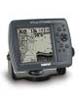
- Receptor GPSMAP 178
- Harta de baza:
Worldwide Marine
- Antena externa cu cablu 10 m
- Transducer 50/200 KHz
- Cablu de date/alimentare
- Suport de montare
- Manual de utilizare
- Scurt ghid de utilizare |
| |
Despre Produs
The GPSMAP® 178 has everything you need in one space-saving package — GPS navigation, marine chartplotting, and powerful sonar. This combination chartplotter/sounder includes the same user-friendly interface as its color counterpart, the GPSMAP 178C, but sports a high-resolution monochrome display and a price thats within any mariners budget.
The GPSMAP 178 packs a built-in worldwide marine basemap, state-of-the art processor with lightening-fast map redraw, and crisp, sunlight readable, 10-level grayscale display into a waterproof, space-saving console — perfect for large crafts and small runabouts alike. Boaters will love its convenient, intuitive design including:
* simple keypad with backlighting for easy operation
* one knob, adjustable tilt and swivel mount so you can quickly pop it in and out
* front loading data cards for easy access
Users can enhance basemap detail on the GPSMAP 178 by simply plugging in data cards preprogrammed with BlueChart® or Fishing Hot Spots® detail or downloading data from optional MapSource CDs to an optional Garmin data card. BlueChart provides exceptional offshore marine coverage that includes shaded depth contours, navaids, shoreline, and more. For inland boating and fishing, the U.S. Recreational Lakes with Fishing Hot Spots CD & preprogrammed data cards are packed with inland lake maps, profiles, marinas, fishing areas and useful outdoor resources.
The GPSMAP 178 is available with either a single or dual-frequency transducer making it the perfect companion for offshore or inland lake fishing. Boaters can choose dedicated full-screen map, full-screen sonar, split-screen map/sonar, compass, and navigational screens — with customizable digital data fields for each page.
Suggested Retail Price:
(Transducers are transom mount. See your retailer for other transducer versions.)
$457.60 (internal antenna with single-frequency transducer)
$514.28 (internal antenna with dual-frequency transducer)
$479.99 (external antenna with single-frequency transducer)
$535.70 (external antenna with dual-frequency transducer)
Caracteristici Produs
- 320 x 320-pixel, high-resolution, 10-level gray-scale FSTN LCD screen with adjustable CCFL backlight
- 3.2" H x 3.2" W (4.5" diagonal) viewing area
- 4.9”H x 6.3”W x 2.8”D unit dimensions
- State-of-the-art 200 MHz processor makes map redraw, panning, and zooming virtually instantaneous
- Accepts Garmin data cards for up to 128 MB of map storage
- WAAS-enabled for accuracy to within 3 meters
- Choose either a dual-frequency 50/200 kHz transducer for offshore boating or a single-frequency 200 kHz transducer for inland lakes and bays
- See-Thru® technology (which separates fish from thermoclines and structure) and Depth Control Gain (DCG®) for detailed images of structure and bottom densities
- New digital display technology offers an easy-to-read, semi-transparent digital readout that allows users to see sonar images "behind" the data
- 3000 user waypoints are automatically tagged with the date and time of creation, as well as water temperature and depth –vital information for serious anglers
- Stores 50 reversible routes with up to 50 waypoints each, plus MOB and TracBack modes
- 10,000 active track points and 700 saved track points; database information can be stored on removable data cards and transferred to a PC or another unit
- Sends, receives, and displays positioning data with DSC equipped VHF radios
- TracBack™ mode helps guide you back to points along a route
- 500-watt (RMS) 4000-watt (PTP) output with dual-frequency transducer
- 400-watt (RMS) 3200-watt (PTP) output with single-frequency transducer
- Adjustable range, gain, zoom, and bottom lock
- Temperature log maintains a graphical record of temperature data
- Water temperature and fish ID with depth alarms
- Waterproof: IEC 60529 IPX7 standards (submersible in one meter of water for up to 30 mins.)
- MapSource compatibility: Compatible with most MapSource products. See the product compatibility table (top, right) for a list of products that Garmin recommends with this software.
|


