|
Pachetul include:

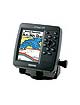
GPSMAP 398C
Preloaded with U.S. marine detail maps (g2 technology)
Internal antenna
Dual beam transducer
Swivel mount bracket
Protective front cover
Power data cable
Owners manual
Quick reference guide
|
| |
Despre Produs
Similar in styling and function to the GPSMAP 292C/298C Sounder, the GPSMAP 398C Sounder along with its counterpart, the GPSMAP 392C, add preloaded U.S. inland freshwater cartography to its enhanced worldwide basemap information. The preloaded inland maps offer 50-meter shoreline resolution throughout the U.S., with even more detailed 10-meter resolution on select lakes. Other details include depth contours, tide and current data, boat ramps, mile markers, hazards, marinas, campgrounds, area roads, and more. Both units accept preprogrammed data cards and are compatible with the latest BlueChart® g2 series marine cartography. The built-in 500-watt (RMS) sounder on the GPSMAP 398C features Ultrascroll™ for high-speed screen updates, and its Garmin CANet™ bus allows sounder display information to be shared with another chartplotter onboard.
Caracteristici Produs
256-color TFT display, 4.0”H x 3.0”W, 5.0-inch diagonal, 320 x 240 pixels
CCFL backlight for display and keypad
Ultra-dim backlight for nighttime operation with user programmable levels for day and night
Unit dimensions: 7.1” H x 6.3” W x 3.1” D (internal antenna)
Power output: 400 watts (RMS) 3200 watts (peak to peak), dual beam
Depth: 900 feet (dual beam)
Transom mount transducer: 80kHz (60 degree), 200kHz (20 degree), dual beam
Built-in Inland maps, provides 50-meter shoreline resolution throughout the U. S., 10-meter shoreline resolution and depth contours on select lakes, USCG light list, wrecks and obstructions, real-time tide and currents, interstates, state highways, and rural roads
CANet proprietary bus allows display and control of full-feature sounder data supplied from Garmin sounder
New sounder design featuring excellent shallow-water performance
Ultra scroll; user adjustable
Adjustable range with automatic display re-scaling of picture
See-Thru technology: shows weak and strong returns simultaneously
Depth Control Grain (DCG): automatically adjusts fishfinder sensitivity according to depth
Power down backup of settings: customer settings are not lost when the unit is turned off
Water temperature log and graph
Round flasher display mode
A-scope
Whiteline
Adjustable depth line
2X and 4X Automatic and manual zoom
Water speed capable
Odometer
Adjustable keel offset
Alarms for fish size, shallow water, deep water, and battery voltage
Battery voltage indication
Detailed fish arches
|
